Saturday 31 March 2012

Mahmud al-Kashgari's(1072) map of the Silk Road ?

On March 28, 2012 I published an item about "The oldest map of the Silk Road?" due to a piece about a conference in 2004 in Zurich, called  Maps and Images in Zurich.
I collected some additional information about this subject from the internet. The map as such is a piece of art but the enlargments of the map are very interesting as well.


Qarakhanid Uyghur scholar Mahmud al-Kashgari compiled a "Compendium of the languages of the Turks" in the 11th century. The manuscript is illustrated with a "Turkocentric" world map, oriented with east (or rather, perhaps, the direction of midsummer sunrise) on top, centered on the ancient city of Balasagun in what is now Kyrgyzstan, showing the Caspian Sea to the north, and Iraq, Azerbaijan, Yemen and Egypt to the west, China and Japan to the east, Hindustan, Kashmir, Gog and Magog to the south. Conventional symbols are used throughout- blue lines for rivers, red lines for mountain ranges etc. The world is shown as encircled by the ocean.[15] The map is now kept at the Pera Museum in Istanbul.
Source: Wikipedia

*******


Mahmud Kashgari’s 11th C. Map of Turkic World
by NATHAN HAMM on 2/28/2007 · Registan.net


Turkic World Map


Click the picture for a larger version.

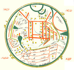
The above map appears in Mahmud Kashgar’s late 11th century Diwan Lugat at-Turk. According to the the 1982 Dankoff translation’s introduction, Kashgari was born near Issyk-kul into a family of the Qarakhanid dynasty. He traveled widely among the Turkic tribes of his time, and his map shows the locations of dialect groups. He split Turkic into two main dialect groups: the Turks and the Oghuz. He believed it necessary for non-Turkic Muslims to learn the language of the Turks.
"…every many of reason must attach himself to them, or else expose himself to their falling arrows. And there is no better way to approach them than by speaking their own tongue, thereby bending their ear, and inclining their heart."

"I heard from one of the trustworthy informants among the Imams of Bukhara, and from another Imam of the people of Nishapur: both of them reported the following tradition, and both had a chain of transmission going back to the Apostle of God, may God bless him and grant him peace. When he was speaking about the signs of the Hour and the trials of the end of Time, and he mentioned the emergence of the Oghuz Turks, he said: “Learn the tongue of the Turks, for their reign will be long.” Now if this Hadith is sound … then the learning it is a religious duty; and if it is not sound, still Wisdom demands it."
Below is another version of the map in English. Click on it for a much larger version. A version that has been rotated so that the top of the map is north can be found at strange maps.

Map of the Turkic World
Click the picture for a larger version

Source: Registan.net
*******


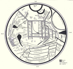
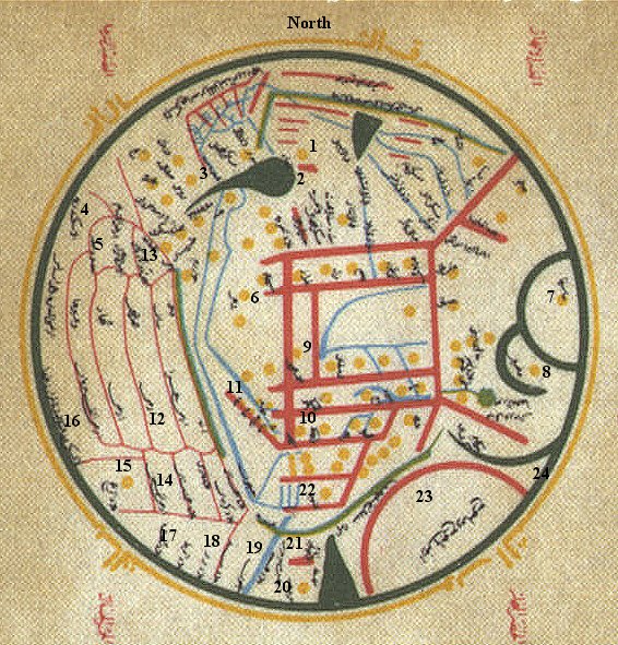
A Key to some of the locations in the map

1. Bulgaria  2. Caspian Sea  3. Rus  4. Alexandria  5. Egypt  6. Tashkent  7. Japan (surrounded by water-the green semicircle  8. China-with water to the west  9. Balasaghun-the center of the world  10. Kashgar-Mahmud's birthplace  11. Samarkand  12. Iraq  13. Azerbaijan  14. Yemen  (15-18 Africa)  15. East Somalia  16. East Sahara  17. Ethiopia  18. North Somalia  (19-22 Indian subcontinent) 19. Indus  20. Hindustan  21. Ceylon and Adam's footprint  22. Kashmir  23. God and Magog  24. the world-encircling sea.
     These and other locations and given in Albert Herrmann, "Die älteste türkische Weltkarte (1076 n. Chr.)," Imago Mundi I(1935)21-28.
     The red mark on the south side of the map (21) identifies the location of the "footprint of Adam," Jebel Serandib, Adam's Peak, on the island of Ceylon, to which Adam was exiled after he was exiled from Paradise. Gog and Magog (23) are a nation and its ruler which represent an apocalyptic evil power, walled off from the world by a range of mountains.


Friday 30 March 2012

Shaxi Town along the centuries-old Silk Road


Making an Old Town New
Shaxi Town along the centuries-old Silk Road forges a new path in restoration
By Yuan Yuan
OVER THE RIVER: Children in Shaxi Town at Yujin Bridge, a centuries-old structure (CFP)


Between two of the best known tourist destinations in southwest China's Yunnan Province, Lijiang and Dali, another ancient town has sat, largely overlooked, for much of the past century.
Shaxi, an extraordinarily well-preserved small town in Jianchuan County, houses treasures, tea houses and architecture that date back more than 1,400 years.
It has been called the only living link left along the Silk Road, an ancient trade route that connected China to West Asia for more than 1,400 years. Located several hours drive from the nearest major city, Shaxi remained extremely isolated until very recently and the town's people, 90 percent of whom are from the Bai ethnic group, therefore maintain a largely traditional way of life.
Despite its rich history and exceptional state of preservation, Shaxi was in fact virtually unknown to outsiders until 2001, when Jacques Feiner from the Swiss Federal Institute of Technology visited this area and realized the historical wealth of the little town.
Ancient and original
"It was so original and so many buildings and sites from its trading days remained," Feiner said.
Shaxi flourished from 1368 to 1911, when it was a major commercial hub on the Silk Road. Nestled in a beautiful green valley with a pleasant climate, the road through Shaxi was the preferred route of caravaners trading in tea and horses.
Traders carrying different goods would meet in the town and exchange their wares at the town fair.
The main market area in the town, Sideng Market, has remained largely unchanged for centuries. In the past whenever trading caravans came to the town, they sold some of their goods for local produce in the evening. Around the market square were dozens of guesthouses, where traders would spend the night.
Nowadays, at night, the locals still gather in the market area to dance and play music and every Friday, the Bai people from all the villages in the Shaxi Valley and the Yi people from the surrounding mountains all come together to trade everything from fresh produce to supplies and horses. Minority women will be dressed in their colorful traditional costumes, and men will often lead pack mules to carry supplies back to their mountain villages, much like in the days of the Tea & Horse Caravan Trail hundreds of years ago.
On one side of the market square sits the Xingjiao Temple, parts of which date back to the early 1400s. It used to be a busy holy place filled with the sounds of chanting and prayers. Also in the square sits the old town's more prominent building, the Sideng Theater, where merchants once gathered to watch operas.
Courtyard homes and guesthouses make up much of the rest of Shaxi. Some of the guesthouses have been in operation for more than 100 years. Comprised of several courtyards, the Laomadian Lodge sits in a 151-year-old building, which was used as accommodation for Silk Road travelers. The guesthouse still houses many of the original cabinets that horsemen slept on top of to guard their personal belongings. White reflecting walls in the courtyards display restored Bai paintings, and, as with all of Shaxi, stepping across the threshold of the inn feels like stepping back through centuries in time.
Careful restoration
After 1949, Shaxi fell into relative isolation. History largely forgot the town over the following decades, and even the early days of tourism in neighboring Dali, Lijiang and Shibaoshan left no trace on Shaxi. This gave Shaxi time to wait for a gentler re-awakening.
In 2001, the World Monument Fund added Shaxi's market square to its Watch List of 100 Most Endangered Sites as the only surviving example of a market town on China's old caravan roads. After that, a team of researchers from the Swiss Federal Institute of Technology and the local Jianchuan County Government launched a $1.3- million Shaxi Valley Rehabilitation Project. The project consists of five parts, marketplace restoration, village preservation, sustainable valley development, ecological sanitation and poverty alleviation.

ANCIENT THEATER: Sideng Theater in Shaxi Town, Jianchuan County in southwest China's Yunnan Province, has a history of more than 1,000 years and still retains its originality (CFP)

The team that restored the city's old town trialed new and original techniques in order to preserve the area's distinct identity. Feiner, who made his name on groundbreaking restoration work in Yemen's Sanaa, insisted on restoration rather than rebuilding, and the use of traditional techniques and materials. "When modern additions are made, they should be clearly visible as such, rather than being made to blend in by using modern methods and a faux-traditional style," he said.
Huang Yinwu, an architect from the same team, echoed this idea. "To keep its originality doesn't mean we disguise the new as something old. It's about keeping the spirit of buildings and sites intact."
From 2003 to 2004, Huang and his team spent a whole year piloting their ideas on two buildings in Shaxi. During the process, they learnt more about the structures and materials used in the old buildings. They selected some craftsmen from the town and employed traditional skills in restoring their original appearances.
After that, Huang's team started to work on the town's most prominent structures—the theater and the gate of Xingjiao Temple.
"Usually in a restoration project, the construction team submits a plan before they begin work," Huang said. "But in this case that wasn't viable as we encountered many new problems during restoration such as leaking roofs and issues of drainage. So we had to constantly adapt our plans."
This painstaking method proved time-consuming and costly. Seeing neighboring regions including Lijiang benefit by demolishing old buildings and rebuilding in a traditional style, the local government became keen to copy the model.
"Lijiang is not a good example for us," Huang said. "Naxi culture is sold to tourists in Lijiang like in a big shopping mall. Development there isn't sustainable. If the tourism boom declines, there will be nothing left of the culture."
In Shaxi, he explained, tourism isn't yet established, and it remains uncertain how it is going to develop. There is no hotel in town, only a few family guesthouses. "We should aim for slow but sustainable development. For the project to succeed long-term, the entire Shaxi Valley, and its historical villages, need a plan for sustainable development, which allow local Bai farmers a way out of poverty without losing their culture," he said.
The local government eventually acknowledged that plans based on mass tourism were not suitable for Shaxi. Feiner and Huang's restoration work continued. Today the market has been drained and relaid, the temple cleaned up and reopened for worship, and the stage is ready once again for local performances. More and more travelers have also begun making their way to the town.

Shaxi Quick Facts
Covering 287 square km, Shaxi Town is home to about 50,000 residents and has a history of more than 1,000 years. People of the Bai ethnic group account for 90 percent of the local population.
The Bai people are mainly agricultural. Their main staple crops are rice and wheat. Their houses are two-storeyed, with the family living on top and livestock below. The style is distinctive, with mud bricks, graceful eaves and tiled roofs. The main Bai religion is worship of local tutelary spirits. Linked with the religious Guanyin Festival, the traditional ceremonies are still alive. Nowadays, the festival is most important for markets, performances, competitions and games.

Source: BeijingReview.com.cn

Sophistication of Ancient Nomads


Ancient Greeks had a word for the people who lived on the wild, arid Eurasian steppes stretching from the Black Sea to the border of China. They were nomads, which meant "roaming about for pasture." They were wanderers and, not infrequently, fierce mounted warriors. Essentially, they were "the other" to the agricultural and increasingly urban civilizations that emerged in the first millennium B.C. 
As the nomads left no writing, no one knows what they called themselves. The nomads were looked down on as an intermediate or an arrested stage in cultural evolution. They had taken a step beyond hunter-gatherers but were well short of settling down to planting and reaping, or the more socially and economically complex life in town. 
But archaeologists in recent years have dispelled notions that nomadic societies were less developed. Grave goods from as early as the eighth century B.C. show that these people were prospering through a mobile pastoral strategy, maintaining networks of cultural exchange with powerful foreign neighbors like the Persians and Chinese. 
Archaeological discoveries dispel the notion that nomadic societies were less developed than sedentary ones. Burial mound in eastern Kazakhstan. A drawing showing the construction of a burial mound, called a kurgan. Zainolla S. Samashev / Margulan Institute of Archaeology

Some of the most illuminating discoveries are coming from burial mounds, called kurgans, in the Altai Mountains of eastern Kazakhstan, near Russia and China. From the quality and workmanship of the artifacts and the number of sacrificed horses, archaeologists have concluded that these were burials of the society's elite in the late fourth and early third centuries B.C. 
Almost half of the 250 objects in a new exhibition, "Nomads and Networks: The Ancient Art and Culture of Kazakhstan," are from these burials of a people known as the Pazyryk culture. The material can be seen through June 3 at the Institute for the Study of the Ancient World at New York University, on loan from Kazakhstan's four national museums. 
Two spectacular examples are 13 gold pieces of personal adornment, known as the Zhalauli treasure of fanciful animal figures; and the Wusun diadem, a gold openwork piece with inlaid semiprecious stones from a burial in the Kargaly Valley in southern Kazakhstan. Artifacts from recent kurgan digs include gold pieces; carved wood and horn; a leather saddle; a leather pillow; and textiles, ceramics and bronzes. Archaeologists said the abundance of prestige goods in the burials showed the strong social differentiation of nomad society. 
Jennifer Y. Chi, the institute's chief curator, writes in the exhibit's catalog that the collection portrays "a world of nomadic groups that, far from being underdeveloped, fused distinct patterns of mobility with apparently sophisticated ritual practices expressive of a close connection to the natural world, to complex burial practices and to established networks and contacts with the outside world." 
The Kazakh conservator of the artifacts, Altynbekov Krym, said that remains in several kurgans were a challenge. "Everything was jumbled together, getting moldy almost immediately," he said, and that it "took six years experimenting to create a new methodology to clean and preserve the material." 
On the most basic level, they moved with the seasons by horse and camel, tending the flocks of sheep and goats that gave them the meat, milk, wool and hides of their pastoral economy. To make the most out of grasslands that were only seasonally productive, they went in small groups into the highland meadows for summer grazing and returned to the lowlands in winter. They crossed broad plains to avoid overgrazing any one marginal pasture. 
As their networks widened, foreign influences, notably Persian, began to appear in nomadic artifacts from the sixth to the fourth centuries B.C. The griffin, for example, originated in the West by way of the Persian Empire, centered in what is now Iran; the nomads modified it to have two heads of birds of prey topped by elk horns. 
The nomads of the first millennium B.C. never failed to apply imaginative touches to the foreign artifacts they acquired. Dr. Chi said the nomads transformed others' fantastic animals into even more fantastic versions: boars curled in teardrop shapes and griffins that seemed to change their parts in a single image. 
By these enigmatic symbols, a prewriting culture communicated its worldview from a vast and ungenerous land that it could never fully tame - any more than these people of the horse were ever ready to settle down.

Source: Chinese Archeology March 27, 2012

Thursday 29 March 2012

Sir Aurel Stein "Collegues and Collections"


Edited by Helen Wang
British Museum Research Publication 184
ISBN 978-086159-1848
© The Trustees of the British Museum 2012


Line drawing of a seal of Pallas Athene
This volume, published to mark the 150th anniversary of the birth of Sir Aurel Stein, presents papers about him, his colleagues and his collections.


Read the introduction (pdf) 
Helen Wang, curator, East Asian Money,
British Museum
Follow the links below to download and read
the full publication.


On Stein, his work and colleagues


Aurel Stein’s Calcutta Connection (pdf)  
Susmita Basu Majumdar, Suchandra Ghosh, Anusua Das

Rai Bahadur Lal Singh: Sir Aurel Stein’s Surveying Companion (pdf) 
Daniel Lal Sander and Stephen Sander (Sukwant Singh)

Recent work on the Stein Collections

Dunhuang Textiles in London: A History of the Collection (pdf) 
Helen Wang, Helen Persson and Frances Wood